  |
|||||||||||
|
|
What we do.
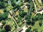
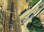
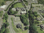
We provide mapping solutions from Aerial Images. These Images are photographed using Survey Specification fully-metricated airborne cameras which produce a 225 mm square format Negative.
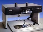
These high resolution images are re-set in our high accuracy Analytical Work Stations or scanned to 20 micron resolution for display in our 'soft-copy' environment.
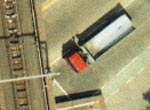
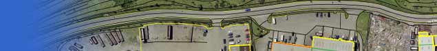
For example if we fly and photograph at 1,000 feet above ground level, from these images we can derive map data as accurate as 25mm RMSE. Our optical systems magnify the detail so that we can easily see small features too. Even down to stop valves and cats-eye reflectors! We capture all the visible features and individually assign each of them to their own layer in a customised data-base. Once we build up the entire map set from all the images needed we edit the data and reprocess it so it arrives at the end-user in a format compatible with the system software in use. We can also reprocess the images so that the end product is not just vector line work, but a dimensionally corrected image, so that measurements and calculations can be made directly from it and we can incorporate the vector mapping too.
We can provide a fly-thru of the project also by draping the rectified photographic image over the surface model. By adding extra data the building and feature shapes are taken into account also and the result produces an amazing 'real-time' effect enabling the viewer to see the site in reality. By making terrain changes and adding 'design data' the viewer can also see the area `as projected'. Our base data is captured in a full 3D environment so every feature has both a plan and a vertical value whether the latter is utilised by the end user or not. |
||||||||||
| © 3Di Imagery to Mapping Ltd. 2012 | designed and hosted by funkyspider | |||||||||||